 Nedbank’s Green Trust is funding a three-year project led by the South African National Biodiversity Institute (SANBI) to create the first national map of our South Africa’s reef systems.
The South African Reef Atlas is based on underwater photographs and gps co-ordinates submitted by ‘reef users’, notably divers, research organisations and government. It will significantly contribute to the improved planning and management of one of South Africa’s most important marine habitats and its biodiversity.
The reef map will take the form of a spatially referenced GIS (Geographic Information System) shapefile that can be overlaid on other existing maps, such as maps reflecting patterns of human use and existing Marine Protected Areas (MPAs).
340 REEF SYSTEMS MAPPED
“To date, approximately 340 reef systems have been mapped and we have 1109 photos with corresponding gps co-ordinates,” says SANBI Marine Projects Officer, Prideel Majiedt, who is leading the Reef Atlas Project together with SANBI’s Marine Programme Manager, Dr Kerry Sink.
Reefs are “features that grow on the seabed, and are built by the interaction of marine life and their environment. For the purpose of this project we have included both natural and artificial systems, notably coral reefs, rocky reefs, kelp beds and wrecks,” explains Majiedt who has a degree in Biodiversity and Conservation Biology. To her credit she learnt to scuba dive at Sodwana Bay at the outset of this project in order to help her manage it.
Approximately 76% of the dive businesses that were approached to participate in the project operate within Marine Protected Areas (MPAs), offering choice diving destinations with ecotourism benefits that need to be carefully managed and conserved. The Table Mountain Nature Reserve is one such MPA.
DRAWING ON RECREATIONAL DIVERS
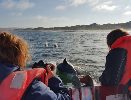
“Our aim was to draw on as many recreational divers as we could to voluntarily participate in the project and to gather the photographs and gps points for us,” Majiedt continues.
“The mapping of the reefs will be a stepping stone to more detailed species mapping, which will be invaluable for the management of reef species, many of which are targeted by the fishing industry.”
Some fish species, such as red stumpnose and red steenbras are resident on reef systems. These species need to be 20-30 years old before they get to a good size. The vulnerability of these and many other slow-growing species speaks for itself.
The Reef Atlas project has already helped to highlight the link between human activity such as fishing, mining and pollution on reef systems and the downward trend of reef biodiversity. By comparing reef maps with maps of human activity, priority areas for management action can be quickly identified. As Majiedt puts it: “The Reef Atlas is an incredibly useful resource to determine where red flags need to be raised.”
REEFS 200 KMS OFF CAPE AGULHAS
The former Marine and Coastal Management (MCM), now the Department of Environmental Affairs and the Department of Agriculture, Forestry and Fisheries, has provided the project with important information about the inaccessible reefs 200 kilometres off Cape Agulhas. They have also offered fisheries data for the West Coast that is used to indicate reefs on this less dived coast.
“We are also exceptionally grateful to the divers, dive schools and research groups who have voluntarily partnered us all the way,” says Majiedt.
The Southern Underwater Research Group (SURG) – a group of divers who share a keen interest in the science and biology of reef systems and species – has provided extensive data from the Cape Town area.
Two other champions of the project are Triton Dive Camp and Zululand Diving, two diving schools in Sodwana, who have also provided extensive data and served as the project’s liaison with other dive operators in the region.
SODWANA REEFS
“We have several well known reefs in the Sodwana area, namely Quartermile, Stringer, Two Mile (the main and most frequently dived reef) Five Mile, Seven Mile, Eight Mile and Nine Mile, each of which have several dive sites and are named according to their distance from the launch site on the beach,” says David Smith a PADI open water diving instructor who established Zululand Diving six years ago.
“The project gives us a good understanding of all the habitats and species. It’s great for divers to be able to participate in the project because we know so much more about what goes on land than in the oceans. The mountains and forests are mapped but our reefs are not,” adds Smith.
“We mainly dive within the MPA in our region and while there are strict diving and fishing regulations in place, I believe a better understanding of the reef systems will help control and monitor the fishing boats and diver impact. Without this, the long-term sustainability and health of the reefs is at risk.”
CLOSE COLLABORATION WITH OTHER WWF/GREEN TRUST PROJECTS
Towards greater marine conservation and effective regulation, the Reef Atlas project is closely collaborating with other WWF/Green Trust projects, such as the Sustainable Seafood Initiative (SASSI), the Fast-tracking of Offshore Marine Protected Areas in South Africa and the 2010 edition of ‘Two Oceans: A Field Guide to Marine Life in Southern Africa’.
“To develop a sound ecosystem approach to our marine resources now and into the future, we need to be able to identify the habitat and distribution of marine organisms and compare this with maps of human activity. This task is impossible without a comprehensive understanding of our marine systems, of which our reef systems are a key component,” explains Majiedt.
BETTER MANAGEMENT OF THE MARINE ENVIRONMENT
The Reef Atlas has been included in the National Spatial Biodiversity Assessment that SANBI produces every five years to report on the threat status of ecosystems and their representation in the MPA network. This will support better management of the coastal and marine environment.
The reef map will be included in a poster that showcases South Africa’s extraordinary reef biodiversity. A scientific report that describes different reef types and lists the main species will also be published. The poster and the report will be freely available in 2011.
